martes, 8 de noviembre de 2011

THE SEASONS

What Causes the Four Seasons?
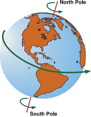
The four seasons are caused by the way the earth spins on it's axis. The tilt is the cause some areas of the earth will receive more sunlight than others.
Why do We have Four Seasons?
We have different seasons because the Earth rotates on its axis. As the Earth turns it gets closer to the sun at times. Then as it keeps going it gets further away from the sun. That’s what makes the seasons change.
What are the Four Seasons of the Year?
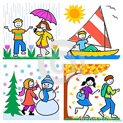
The four seasons of the year are Fall, Winter, Spring and Summer. Summer tends to be the hottest; winter is the coldest. Spring has nice warm temperatures and Fall has those temperatures that are just beginning to cool down.


CAQUETA, GUAVIARE AND GUAINÍA

CAQUETÁ DEPARTMENT


Caquetá is a department of Colombia. Located in the Amazonas region, Caquetá borders with the departments of Cauca and Huila to the west, the department of Meta to the north, the department of Guaviare to the northeast, the department of Vaupés to the east, the departments of Amazonas and Putumayo to the south.
Caquetá has 16 municipalities (Florencia, Albania, San Vicente del Caguan, etc). Its capital is FLORENCIA.
The main economy is mining, agriculture and cattle farming.

GUAVIARE DEPARTMENT

It is located in the Amazon region. At the north of this department is located Meta and Vichada; at the west Caquetá and Meta; and at the south is Caquetá and Vaupés.
Its capital is San José del Guaviare. Guaviare has 4 municipalities (San José del Guaviare, Miraflores, Calamar y el Retorno).
The main economy is agriculture, cattle farming and forestry.

GUAINIA DEPARTMENT
It is in the east of the country, bordering Venezuela and Brazil. Its capital is Puerto Inirida. The department is known for its coca crops and the guerrilla presence, but many in Colombia ignore the beauty landscape, the variety in food and the Indians deep sense of hospitality.
There's only one municipality in Guainía: Inírida, the capital.
The main economy is agriculture and cattle farming.


viernes, 4 de noviembre de 2011

EL CAFÉ COMO EMBLEMA NACIONAL

                           CAFÉ COLOMBIANO


El café es una de las bebidas más consumidas a nivel mundial y aunque Colombia se considera como uno de los mejores productores, es a su vez uno de los países que menos lo consume.
El café colombiano es reconocido como el mejor café del mundo y en varios países como una excelencia gastronómica
El café viene de diferentes plantas o arbustos que se dan en la región tropical llamada el Eje cafetero de Colombia., la cual se extiende a lo largo de las pendientes de las cordilleras en el clima templado, concentrándose especialmente en los departamentos de, Caldas, Risaralda y Quindío. También Antioquia, Tolima y Valle del Cauca son productores de café.
Datos
  • Zona cafetera: 3'050.141 hectáreas
  • Área café: 875.000 hectáreas
  • Producción: 12'200.000 sacos (1 saco = 60 kg.).
  • Municipios cafeteros: 590
  • Caficultores: 514.000
  • Destino exportación: 40 países
  • Duración para tostar el grano: 10 a 20 minutos -Temperatura: entre 400º F y 425º F.
Juan Valdéz. Personaje creado por la Federación Nacional de Cafeteros de Colombia para promover las ventas de café en el exterior. Representa al típico campesino de la región cafetera colombiana que acompañado de un burro trasporta los sacos de café.

LA FLOR NACIONAL

LA ORQUÍDEA CATTLEYA TRIANAE
La Orquídea Cattleya Trianae es una planta epífita de hojas carnosas, oriunda de Colombia, de hermosas flores. Fue escogida como flor nacional según un concepto emitido por la Academia Colombiana de Historia en 1936. Debe su nombre al jardinero inglés Mr. W. Cattley, quien ocasionalmente la cultivó y divulgó en Europa y al naturalista colombiano José Jerónimo Triana.  
Aunque no hay ningún decreto o ley que la haya escogido como la flor nacional, culturalmente así ha sido aceptada. Sin embargo, está en peligro de extinción.

Es sabido que las Orquídeas Colombianas están señaladas entre las más hermosas del mundo. La estructura y los colores de la Cattleya Trianae son de una extraordinaria belleza.

CARACTERÍSTICAS GENERALES
Al género Cattleya pertenecen plantas originarias de las zonas tropicales del Sur y de Centro América.
Las orquídeas Cattleya necesitan temperaturas adecuadas, durante el invierno, alrededor de 13-15°C cómo temperaturas mínimas y 22-23°C como máximas. En verano, las temperaturas no deberían superar 30-32°C. Es importante que el cambio entre día y noche no sea superior a 5-6 °C.

jueves, 3 de noviembre de 2011

EL MONACATO

El monacato proviene de la vida solitaria altamente cristiana con el continuo esfuerzo para llegar a la perfección espiritual. El monje (o la monja) es la persona que ha rehusado (abnegado) el mundo para dedicarse a la oración y al cumplimiento de todos los mandamientos evangélicos, incluyendo la obediencia (la negación de su propia voluntad), la paciencia y la castidad. Por cuanto la meta del monacato en resumen consiste en la imitación de Cristo, los monjes que pudieron llegar a tal bienaventurado estado se denominan imitadores (de Cristo).
                          

AMAZONAS DEPARTMENT

                                                              
It is located at the South of Colombia. At the North of Amazonas is located Caquetá and Vaupés; at the South the Amazonas River; at the East Brasil and at the West is located Putumayo and Perú.
Amazonas has two municipalities: Leticia and Puerto Nariño.
The capital of this department is Leticia. From 1991 Amazonas was recognized as department. The main economical activities are: fishing, tourism, agriculture and forest exploitation.
Francisco de Arellano explored this department in 1524.
We can arrive to Leticia by plane, it takes one hour and forty five minutes.

VICHADA DEPARMENT

                                                         
Vichada is located in the Orinoquia region within the Orinoco river basin bordering the Bolivarian Republic of Venezuela to the north and east. To the north the department of Vichada also borders to the north with the department of Arauca, to the northwest with the department of Casanare, to the west with the department of Meta, to the southwest narrowly bordering with the department of Guaviare and to the south with the department of Guainía.
The capital of the department is Puerto Carreño. The department is subdivided into four municipalities; Puerto Carreño, La Primavera, Santa Rosalía and Cumaribo.
Climate in the Department of Vichada is predominantly hot and humid with an average temperature of 28 °C (82 °F) throughout the year.
The main activities in this department are: agriculture, cattle farming, fishing and crude oil production.

VAUPÉS DEPARTMENT

                                    
It is bounded by Guainía department (north), Brazil (east), the Apoporis River (south), and Guaviare department (west).
The capital is Mitú; Vaupés has 3 municipalities.
The main economic activities of Vaupés are subsistence agriculture, fishing, forestry, and the collection of plants for medicinal and traditional purposes.
The first conquistador in arriving to this department was Hernán Pérez de Quesada in 1538.

ACTIVITY TO FINISH AT HOME

Complete the chart.
How many flat surfaces, edges…. Etc, each solid figure have?
SOLID FIGURE
FLAT SURFACES
CURVED SURFACES
EDGES
VERTICES
1.    CUBE


2.    RECTANGULAR PRISM


3.     SQUARE PYRAMID


4.     CYLINDER


5.     SPHERE


6.     CONE


ACTIVITY ABOUT AREA AND PERIMETER

En el siguiente link encontrarán la actividad de Área y Perímetro que se trabajó en clase el 2 de Noviembre.

https://docs.google.com/document/d/1eyzQ95-uJOpE97pwnFPIYaYLKHowhrZ69ZFMwjpQGYM/edit

PERIMETER AND AREA

PERIMETER:  Is the distance around a plane figure. We have to add the lengths of the sides to find the perimeter.
AREA: Is the number of square units needed to cover a surface. You can count the number of squares units to find the area. You can find the area of a rectangle by multiplying the length by the width. It is measured in square (Sq) units; some of these units are: squared centimeters (Cm2); squeared metres (m2) and squared kilometers (km2).
Example:

miércoles, 2 de noviembre de 2011

THE EARTH’S MOTION

THE EARTH’S MOTION

1. ROTATION: It is the movement made by the Earth when it spins around its own axis, creating the day and night cycle. This movement lasts 24 hours. When the Earth rotates, a half of the planet is always enlighten, while the other half is dark.


1. REVOLUTION: it is the orbital motion made by Earth turning around the Sun. it takes 365 days and 6 hours. This time period is called a YEAR.
Civil Year: it has 365 days and 6 hours.
Leap – year: it has 366 days and happens every four year.

LAYERS OF THE EARTH

1.       Atmosphere: it is the gaseous layer surrounding the Earth planet. It is made of several gases, mainly Nitrogen and oxygen.

2.       Hydrosphere: It is the huge mass of water that covers three quarters (3/4) of the planet surface. The Hydrosphere is essential for maintaining living things cycles and nutrient cycles in the planet.


3.       Crust: it is a layer extending from the surface to 33 km deep. It is divided in 2 parts: the Upper zone (forming the continents) and the Lower zone.

4.       Mantle: it is an intermediate layer situated between the lithosphere and the core.

5.       Core: this part of the Earth is unknown because nobody have reached that deep inside. It has a high temperature coming from the remaining heat on planet formation and decaying radioactive elements.